
Standard Operating Procedures - Aerial Cover Survey
KEY DETAILS
- Principal Investigator
- Dr. Nicola Stevens, Dr. Megha Ojha
Date - 1 June 2025
Version - 1.1.0
Programme - Rangelands Biodiversity Programme
Key partners - LCNR, Kew Gardens, University of Liverpool, Harvard University Contact email
- nicolastvns@gmail.com
1. PREAMBLE
Natural State’s research methods and activities are detailed by a set of accepted Standard Operating Procedures (SOPs). These documents describe the steps involved in all Natural State research methodologies, from data collection to data processing and storage. Each SOP documents key methodological details for a specific data type. The objectives and background of the projects or surveys these methods are used for, features of the study area where these methods are applied, and details on survey and sampling designs for these methods may be found in survey Design Documents (DDs), which are available in the Related Documents section below or may be perused in the main NS Design Documents documentation page.
2. GLOSSARY
3. METHODS OVERVIEW
The aerial cover survey will provide ground truth data for the remote sensing component of the functional trait campaign. Aerial cover estimates of herbaceous species will be taken from twelve quadrats per plot. Vegetation height will also be measured in each quadrat, and a disk pasture meter will be used to record herbaceous biomass. The corner coordinates of each quadrat will be with an RTK GPS to that the aerial cover data can be accurately matched to remotely sensed data. The Aerial Cover Survey should be completed before the Vegetation Functional Traits Field Survey as the aerial cover data is required to determine which species need to be sampled for functional traits.
3.1 METHOD AIMS
The aerial cover survey is designed to:
- Document the identity and aerial cover of herbaceous species in quadrats.
- Document vegetation height in 5 points within each quadrat.
- Document herbaceous biomass using a disk pasture meter.
- Document the corner points of each quadrat for linking to remotely sensed data.
3.2 METHODOLOGICAL BACKGROUND
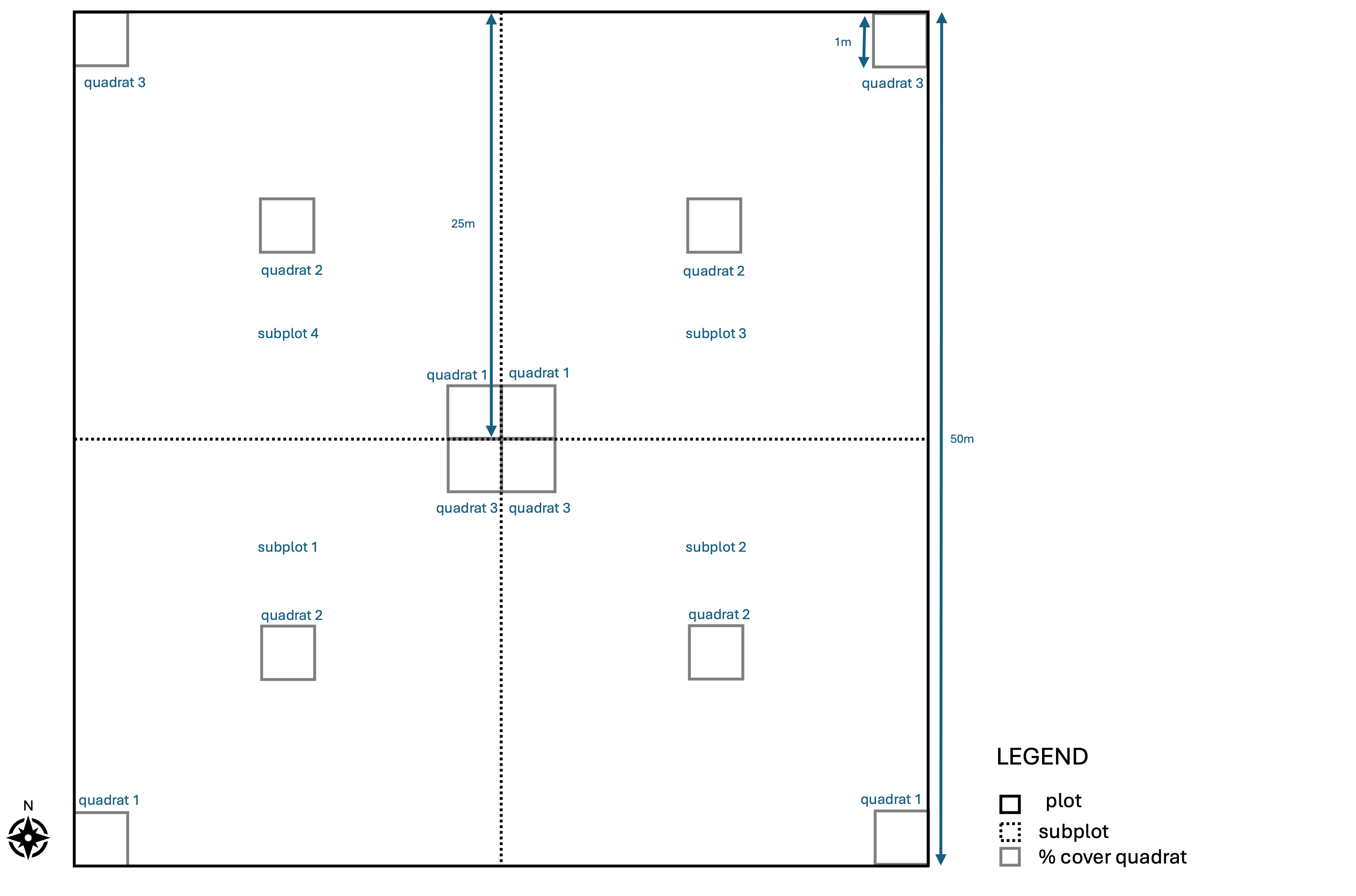
These methods for monitoring vegetation have been adapted from the NEON Plant diversity sampling protocol. The methodology requires the establishment 50 m X 50 m plots, each containing 12 1m X 1m quadrats. Herbaceous species presence and percentage cover is then recorded in quadrats as is vegetation height. This methodology has been developed in a way that will allow it to be linked to aerial data from drones, planes or satellites in the future.
4. SAMPLING PREPARATION
The equipment mentioned in the list below needs to be gathered, checked and packed before sampling begins. If any sensors need to be configured prior to commencing sampling this will be documented below the equipment list.
4.1 EQUIPMENT LIST
- GEM plot QR codes
- Tablet with S123 loaded and a functional camera
- RTK GPS
- 6 X 50 m measuring tapes
- 1 m X 1 m metal quadrat
- 1.5 m tall tripod
- 2 m long measuring stick
- Disk pasture meter
- Compass
4.2 DEVICE CONFIGURATION
- The S123 app needs to be loaded onto the tablet and the Aerial Cover Survey FTC and DPM Survey FTC need to be loaded.
5. SAMPLING PROCEDURES
These methods for monitoring aerial cover require establishing 50 m X 50 m plots, each containing 12 1 m X 1 m quadrats. All trees within the plot will be ignored in this survey as they have been recorded in other surveys at the same plots. All grasses and forbs should be recorded to species level in each 1 m² quadrat and the aerial percentage cover of each species should be recorded. The aerial cover survey will take place at all plots included in the functional trait campaign: all GEMS, the three plots in Leparua and the three control sites in Maiyanat.
5.1 AERIAL COVER SURVEY
- Navigate to the centre point of the plot.
- Establish the extent of the 50 m X 50 m plot by running a 50 m measuring tape 25 m north and 25 m south and by running a second one 25 m east and 25 m west, intersecting at the plot centroid. Find corner plot markers for each subplot
- Open the S123 App, connect the RTK GPS and collect the metadata required by the Aerial Cover Survey FTC.
- Stand at the centroid of the plot and taking a photograph of each subplot.
- Start in subplot 1 quadrat 1, according to the figure above. Subplots are labelled from 1 to 4, starting in the south west corner and moving in an anti-clockwise direction. Of the 3 quadrats in each sublplot, quadrat 1 is always furthest south.
- Place the 1 m X 1 m metal quadrat flat on the ground so that it sits flush with the surface, as indicated in the figure above. If the quadrat initially overlaps a tree stem, slide it toward the plot’s center until the stem lies just outside the frame (the quadrat may abut the stem but must not include it). Quadrats should also avoid shrubs. Ensure that at least 6 of all the quadrats are not under a tree. The location of the quadrats is a guide so if they need to be moved (e.g. a tree/rhino midden) please move then over accordingly.
- Record the coordinates of all corners of the quadrat in S123 using the RTK rover. Start at the south west corner and move in an anti-clockwise direction. It is important that the RTK rover is placed exactly on each corner of the quadrat.
- Take 5 vegetation height readings from the quadrat: one from each corner and one from the centroid. Each vegetation height reading should be taken at the point where 80% of the herbaceous leaf table height sits. Start at the south west corner and move in an anti-clockwise direction, and then to the centroid.
- Estimate the percentage bare ground (anything that is not alive) at the quadrat scale.
- Estimate the percentage of the quadrat that is covered by tree canopy.
- Stand directly above the quadrat and look vertically downward. For each species present, estimate the percentage of ground covered by its living herbaceous vegetation (the vertical projection). Account for overlapping foliage correctly: because of multiple canopy layers, total cover for all species in a quadrat may exceed 100 %. Species present in the plot but occupying very little space should have their aerial cover recorded as 0.5%. If a species name is not present within the dropdown list in S123 select ‘other’ and type in its name. If a species cannot be identified select ‘other’ and record a more general name, such a ‘species_1’ and take a sample for identification back at the office with the help of a book or expert. Every new unidentified species needs a new number. Do not reuse numbers unless it is the same species! A list of how more general names map to species names must then be provided to the project PI.
- Repeat steps 6-10 at quadrat 2 in subplot 1, then at quadrat 3 in subplot 1.
- Move to subplot 2, then 3, then 4, repeating steps 6-11 in each subplot.
- Pack up equipment and move to the next plot.
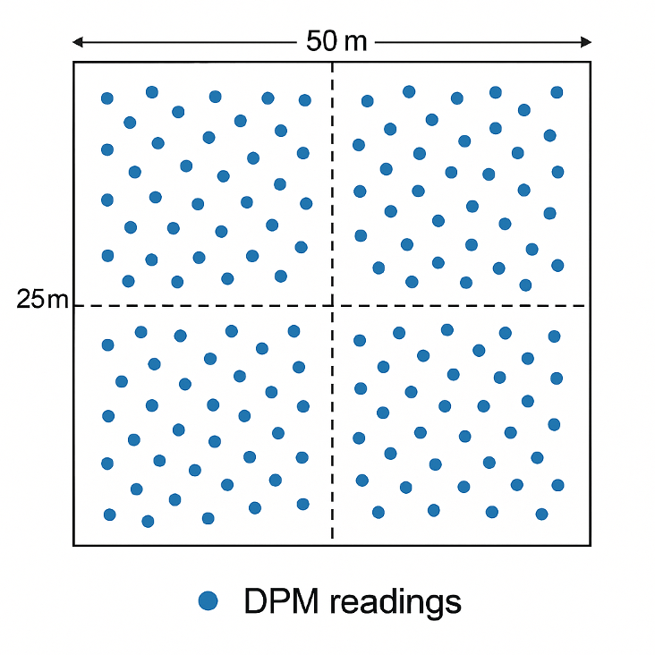
5.1 DISK PASTURE METER SURVEY
- Open the DPM Survey FTC 123 form.
- Use the disc pasture meter to collect 100 readings spread evenly across the plot (25 per subplot).
- Pack up equipment and move to the next plot.
6. POST PROCESSING
Any plant species recorded at plots that did not previously exist in the species list should be sent to the project PI to be added to the choices list in S123.
This data needs to be used to identify the herbaceous species that account for 95% of the aerial cover within each plot. These species will then be sampled during the Vegetation Functional Trait Field Survey.
6.1 SAMPLE PROCESSING AND STORAGE
Any plant samples taken for identification need to be identified using a book or expert consultation. A spreadsheet linking field names (species_1) to actual names needs to be provided to the project PI.
6.2 DATA ENTRY AND UPLOADS
S123 forms need to be sent to the cloud upon return to internet or cell phone reception.
7. RELATED DOCUMENTS
7.1 DESIGN DOCUMENTS
7.2 OTHER RELEVANT SOPS
7.3 DATA ELEMENTS
Survey Design
Data Collection
Dashboard
8. REVISION AND VERSION HISTORY AND DESCRIPTION
v1.0.0 Initial SOP created in May 2025. v1.1.0 Modifications after in person meeting on first day of trait campaign in June 2025.