
Before-After Control-Impact Survey of Elephant Exclosures
KEY DETAILS
- Principal Investigator
- Dr. Matthew Rogan
Date - 15 January 2024
Version - 2.0.0
Programme - Rangelands Biodiversity Project (RBP)
Study Site - Lewa-Lolldaiga-Borana-Ngare Ndare (LLBN)
Key partners - Lewa Wildlife Conservancy
Contact email - mrogan@naturalstate.org
1. PREAMBLE
Natural State’s objectives and activities are governed by a set of accepted Design Documents (DDs). These documents describe the context and purpose of all Natural State projects. Each DD documents key project details, the objective and background of the project, features of the study area, and the general methodological framework. Specific methodological details may be found in the project Standard Operating Procedures (SOP) which is available in the Related Documents section below.
2. GLOSSARY
See Natural State main glossary (Not yet live on Documentation Website.)
3. PROJECT OVERVIEW
3.1 PROJECT AIMS
The Before-After Control-Impact Survey of Elephant Exclosures aims to:
- Determine the effect of elephant and large-mammal exclosures on biodiversity using the gold standard Before-After Control-Impact (BACI) experimental design.
- Collect longitudinal data to model changes over time in carbon and biodiversity in response to management interventions.
3.2 PROJECT BACKGROUND
Lewa Wildlife Conservancy (hereafter ‘Lewa’) erects fences to restrict the movement of elephants or of most medium-large mammals within certain sections of the conservancy. These fences serve a range of management goals including reducing animal activity in unsafe areas and creating woodland habitat by reducing elephant damage to trees. Lewa uses a variety of fence types such as a single pair of electrified cables above the height of all mammals except for giraffe and elephants, or densely packed X-shape cables anchored to low wooden fences that inhibit the movement of most mammals that weight 10 kg or more. Recently, Lewa has decided to expand exclosures in two large areas of the conservancy with an aim to restoring tree cover in line with levels last seen in the 1980s before the rapid growth of the elephant population.
The before-after control-impact (BACI) experimental design is the most robust approach to measure the effect of interventions in nature. Natural State will collect data under the BACI framework within these extensions of Lewa’s exclosures as part of a long-term project to investigate the effects of these exclosures on biodiversity. The datasets collected as part of this survey will be instrumental in training and validating models of biodiversity change that can underpin novel financial mechanisms to support large-scale restoration.
3.3 STUDY AREA
The Lewa-Lolldaiga-Borana-Ngare Ndare (LLBN) study site is a savanna rangeland landscape in the central highlands of Kenya that extends north from the lower slopes of Mt. Kenya, straddling the boundary between Meru and Laikipia counties. The four main properties are located at 0.11 = 0.34° latitude and 37.07-37.53° longitude.
Rainfall is highly variable, but is typically between 400 and 600 mm annually. During droughts, total annual rainfall can drop below 200 mm. Rainfall generally follows a north-south gradient with more rainfall at higher elevations in the south. The landscape sits at 1400-2370 m with higher elevations in Ngare-Ndare forest and south-central Lolldaiga and the lowest elevations in Lewa and northeast Borana. Soil types are highly variable throughout the landscape but consist primarily of Luvisols (Haplic and Vertic) and Dystric Regosols. Vegetation communities are predominantly Acacia-Commiphora bushlands and thickets with montane forests at higher elevations (Dinerstein et al. 2017).
Each of the four core properties are subject to divergent management practices. Lewa Wildlife Conservancy is mostly owned by The Nature Conservancy but has a number of small, privately owned enclaves. The reserve is almost exclusively used for photographic tourism but does have some livestock grazing, especially along the community road and in a section nicknamed ‘Bosnia’ where the community have grazing rights. Over the last 30 years, the conservancy has increasingly adopted elephant and large-mammal exclosures as a major management practice aimed at increasing tree cover on the conservancy.
Lolldaiga ranch is principally a livestock ranch but is also used by free ranging wildlife. Historically, the ranch was intensively grazed but recently new management has implemented a regenerative grazing regime based on intensive grazing by a few large, fast-moving herds. The grazing regime is intended to stimulate grass productivity and prevent selective grazing by livestock herds.
Borana Conservancy is a dual use wildlife and livestock ranch that also includes privately owned enclaves. In addition to photographic tourism, the conservancy produces cattle and has a partnership with a local community that extends limiting grazing rights to community herders. Borana has a few large-mammal exclosures, especially along the river that runs between Lewa and Borana.
Ngare-Ndare forest is a state forest reserve but is managed by the Ngare-Ndare Forest Trust on behalf of six villages. The Trust administers sustainable use of the forest by the six communities, predominantly for firewood collection and grazing. The forest also has small-scale tourism operations. The forest is predominantly populated with wild olives and junipers.
North of Lewa, Borana, and Lolldaiga are several community conservancies that practice predominatly pastoral lifestyles as well as the Mukogodo Forest, which is a forest conservancy managed on behalf of four neighboring communities. On the western boundary of Lolldaiga Ranch is Kupona, a small experiemental plot for testing restoration interventions.
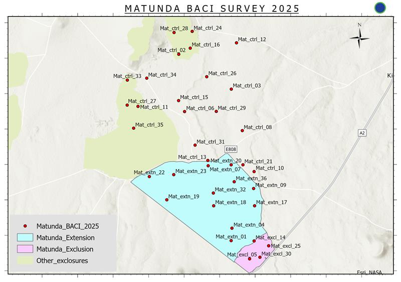
Matunda Zone The Matunda extension is planned for 2025 covering the wedge in southeastern Lewa that extends from the pre-existing Matunda exclosure north to the community road that runs east-west between the conservancy boundary and Lewa HQ exclosure. To the east it is bounded by the road that runs southeast from the community road to the gate at the TM gate and from the TM gate south along the Lewa boundary to the Matunda exclosure.
Existing exclosures representative of the area are the original Matunda exclosure, Lewa HQ, and Digby’s. The three form a triangle and encompass the exclosure and control areas.
The ‘control’ area was created by Matt Rogan and runs from the community road north to Digby’s and is bounded to the west by Lewa HQ and the Lewa HQ airstrip. It also includes the small wedge that is east of the TM gate road and south of the community road.
Where suitable, legacy stations were inherited from the 2022 Lewa Exclosure Pilot Survey and the 2024 Carbon Pool Plots.
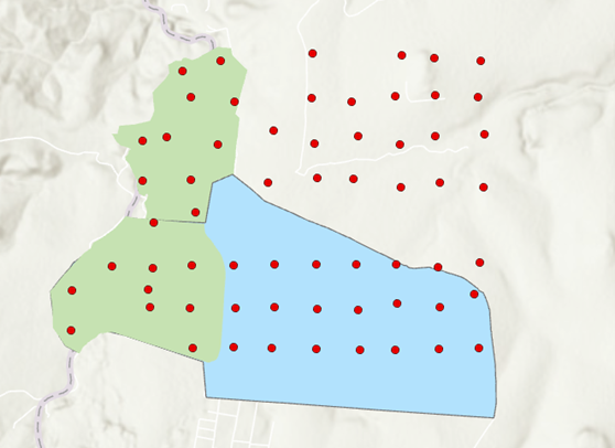
Kona Safi Zone The Kona Safi Zone consists of the original Kona Safi exclosure and Rose Dyer exclosure along the border of Lewa and Borana conservancies (‘pre-existing exclsoures’, 483 ha), the 2022 extension of the Kona Safi exclosure (‘extension’, 684 ha), and the area north of the extension and east of Rose Dyer exclosure that was characterized as the “Control West North” zone during the 2022 exclosure survey (‘control’, 840 ha). The area was sampled in 2022 as part of the Lewa Exclosure Pilot Survey prior to the Kona Safi extension and prior to the development of the BACI survey. Sampling consisted of only camera-traps at sufficient intensities for analyses. The Exclosure pilot survey used an approximate clustered grid design with spacing of ~500 m.
3.4 PROJECT TIMELINE
Matunda Zone Baseline: February 2025 Intervention Date: TBD Post-intervention follow up: TBD
Kona Safi Zone Baseline: 2022 Intervention Date: October 2022 Post-intervention follow up: October 2025
4. SURVEY DESIGN
The BACI survey consists of a set of semi-independent surveys, with each semi-independent survey determined by the construction of a new or extended exclosure and consisting of spatially replicated sampling within a set of treatments and temporally replicated sampling with a ‘before’ baseline sampled before the treatment takes effect (i.e., before the new or extended exclosure is built) and one or more ‘after’ replicates occurring at intervals greater than the expected temporal scale of impacts resulting from the treatment.
4.1 SPATIAL DESIGN
The BACI survey is subdivided into a set of ‘zones.’ Each zone is named after the new or extended exclosure (e.g., “Matunda” or “Kona Safi”). A zone consists of the clearly delineated treatment and control areas as indicated below; (i) within pre-existing exclosures (hereafter ‘exclosures’), (ii) within the area designated for the new or expanded exclosure (hereafter ‘extension’) (iii) in areas immediately outside the expanded exclosure where there are no evident plans to erect exclosures for at least five years (hereafter ‘control’). In some cases it may be necessary to exclude the pre-existing exclosure treatment if no representative, proximal exclosures are available for sampling.
All sampling stations should be chosen according to stratified random sampling with sampling stratified by treatment, or drawn from sampling locations of other surveys that also employed a stratified random sampling approach. Sampling effort should be approximately equivalent in each of the three treatments.
Station selection Whenever possible, will be be placed at pre-existing station locations to maximize the longitudinal richness of the dataset so long as those stations also were selected according to a random or pseudo-random design. However, doing so should never compromise the spatial balance and independence of the sampling design. All stations within a treatment should be independent meaning that they should be spaced a minimum of 300 m apart and preferably 500 m. The number of stations per treatment should be determined at the discretion of the survey designer based on the size and heterogeneity of the survey zone.
Field teams should exercise their judgement in situating recorders, especially bioacoustics recorders. When using a pre-existing station, attention should be paid to replicating the prior sampling as best as possible. At new stations, however, the field team should exercise their judgement in choosing the bast placement of the recorder relative to the layout of the area in the immediate vicinity of the station (e.g., within 100 m). However, field teams should be careful that they maintain sufficient distance (> 300 m) between recorders, especially in the case of AudioMoths. Camera-traps, bioacoustic recorders, and vegetation sampling need not co-occur but doing so will often be practical.
Kona Safi Zone Camera Stations
4.2 TEMPORAL DESIGN
Sampling should occur immediately prior to the exclosure being built or extended, and then again 3, 5, and 10 years after. Stations and sampling methodologies should remain fixed between temporal replicates.
5. SAMPLING DESIGN
Sampling within each zone should generally follow standard NS protocols for passive recorders but there is some flexibility so long as the sampling for each zone is consistent across treatments and through time. Once a baseline survey is collected within a zone, that protocol should remain in place for that zone for all future sampling.
5.1 Camera Trapping
All camera trapping will follow standard NS camera-trapping protocols. All sensors will be designated as type ‘float’ meaning that field team members should exercise their judgement in identifying the best location for a camera within 100 m.
5.2 Passive Acoustic Monitoring
All PAM will follow standard NS PAM protocols. All sensors will be designated as type ‘float’ meaning that field team members should exercise their judgement in identifying the best location for a camera within 100 m.
5.3 Vegetation Surveys
All vegetation surveys should be drawn from individual components of the Carbon Pool Plots protocol.
5.3 Pitfall trapping
All pitfall trapping should follow [standard NS pitfall protocols(https://docs.naturalstate.tech/docs/standard-operating-procedures/06_SOP_RBP_IPT.html)].
6. ANALYTICAL FRAMEWORK
Data will be analysed using a variety of hierarchical ecological models such as multiseason occupancy or community abundance models. Trends in species distribution will also be assessed using the mean change in proportion of area occupied across species within a functional group.
7. EXPECTED OUTPUTS
==XXX==
8. RELATED DOCUMENTS
8.1 STANDARD OPERATING PROCEDURES
- Camera-trapping SOP
- PAM SOP
- CPP Large tree survey (link not currently available)
- CPP Transect survey (link not currently available)
- CPP Bare Ground and Disc Pasture Meter Survey (link not currently available)
- Pitfall-trapping SOP
8.2 OUTPUTS
==XXX==
8.3 DATA ELEMENTS
Survey Design
Data Collection
- S123 data collection form - Camera trapping
- S123 data collection form - PAM
- S123 data collection form - Pitfall trapping
- S123 data collection form - CPP transect survey
- S123 data collection form - CPP large tree survey
- S123 data collection form - Bare Ground and DPM Survey
Data Layers
==XXX==
Dashboard
==XXX==
8.4 ADMINISTRATIVE DOCUMENTS
==XXX==
9. REVISION AND VERSION HISTORY AND DESCRIPTION
- Version 1.0.0 pre-existed the NS documentation portal and was based on an outdated plan for the Matunda Extension and based on outdated sensor protocols.
- Version 2.0.0 is updated to reflect the revised design of the Matunda Extension and to incorporate the latest NS protocols and documentation.
10. BIBLIOGRAPHY
==XXX==
11. APPENDICES
None currently available