
Design Document - Global Ecosystem Monitoring
KEY DETAILS
- Principal Investigator
- Prof. Nikki Stevens, Prof. Kate Parr, Dr. Matt Rogan
Date - 13 August 2025
Version - v1.0.1
Programme - Rangelands Carbon Programme
Study Site - Lewa-Lolldaiga-Borana-Ngare Ndare (LLBN)
Key partners - LCNR; University of Liverpool; ICRAF
Contact email - mrogan@naturalstate.org
1. PREAMBLE
Natural State’s objectives and activities are governed by a set of accepted Design Documents (DDs). These documents describe the context and purpose of all Natural State projects. Each DD documents key project details, the objective and background of the project, features of the study area, and the general methodological framework. Specific methodological details may be found in the project Standard Operating Procedures (SOP) which is available in the Related Documents section below.
2. GLOSSARY
3. PROJECT OVERVIEW
3.1 PROJECT AIMS
The Global Ecosystem Monitoring (GEM) project aims to:
- Measure rates of carbon and nutrient cycling in tropical rangelands under different herbivory and soil regimes.
- Measure Net Primary Productivity (NPP) in tropical rangelands under different herbivory and soil regimes.
- Provide long-term high-frequency monitoring plots for trialling new ecological and carbon monitoring technologies.
3.2 PROJECT BACKGROUND
Tropical savannas and rangelands are highly productive and biodiverse yet remain far less studied than many other biomes such as tropical forests. We lack an in depth understanding of carbon dynamics and biological intactness in these systems. This deficit undermines efforts to expand voluntary carbon and biodiversity markets across much of Africa without sacrificing the quality of impact monitoring. Natural State is working to develop impact monitoring systems for aboveground and belowground carbon in African savannas and rangelands to enhance transparency and accountability in carbon projects reporting. This research project aims to generate comprehensive, multi-trophic evaluation of carbon stocks, fluxes and energy flows under contrasting herbivore regimes in East African savannas.
The Global Ecosystems Monitoring Network represents a global, in-depth monitoring protocol to fully understand the carbon cycle in natural systems by measuring primary productivity and carbon and nutrient cycling. It provides comparable datasets across biomes that allow scientists to untangle complex ecosystem dynamics. Originally developed for neotropical forests, here we present a version of the GEM survey methodology adapted for tropical rangelands.
GEM plots are used to quantify key components of ecosystem productivity, through routine measurements at relatively high frequency (biweekly/monthly/quarterly/annually, depending on site and measurement type). We propose to measure the main components of Net Primary Productivity (NPP) (e.g., canopy litterfall, woody growth and fine root productivity), as well as the main components of ecosystem respiration (woody stem respiration, leaf respiration, grass, and soil respiration), which enable estimations of total autotrophic respiration. The summation of autotrophic respiration and NPP gives an estimation of Gross Primary Productivity.
Natural state is implementing the GEM plots to investigate cycling of carbon in relation to herbivory regimes and to generate data required for development of remote sensing-based models for prediction of changes carbon at scale as well long-term monitoring of carbon cycling in savanna systems.
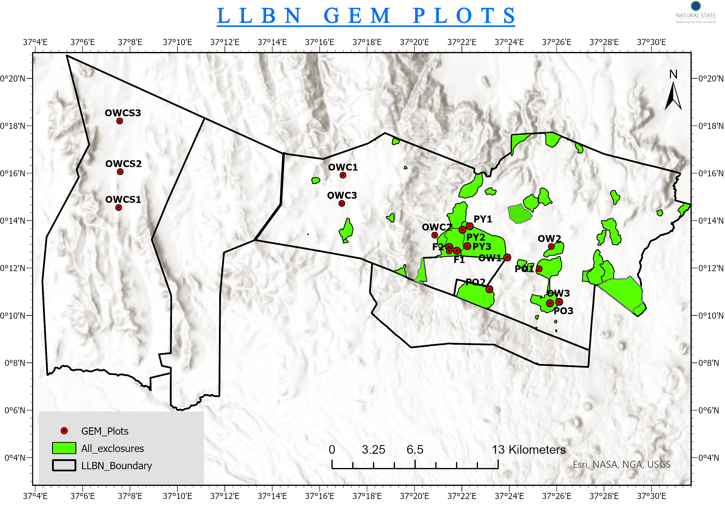
3.3 STUDY AREA
The Lewa-Lolldaiga-Borana-Ngare Ndare (LLBN) study site is a savanna rangeland landscape in the central highlands of Kenya that extends north from the lower slopes of Mt. Kenya, straddling the boundary between Meru and Laikipia counties. The four main properties are located at 0.11 = 0.34° latitude and 37.07-37.53° longitude.
Rainfall is highly variable, but is typically between 400 and 600 mm annually. During droughts, total annual rainfall can drop below 200 mm. Rainfall generally follows a north-south gradient with more rainfall at higher elevations in the south. The landscape sits at 1400-2370 m with higher elevations in Ngare-Ndare forest and south-central Lolldaiga and the lowest elevations in Lewa and northeast Borana. Soil types are highly variable throughout the landscape but consist primarily of Luvisols (Haplic and Vertic) and Dystric Regosols. Vegetation communities are predominantly Acacia-Commiphora bushlands and thickets with montane forests at higher elevations (Dinerstein et al. 2017).
Each of the four core properties are subject to divergent management practices. Lewa Wildlife Conservancy is mostly owned by The Nature Conservancy but has a number of small, privately owned enclaves. The reserve is almost exclusively used for photographic tourism but does have some livestock grazing, especially along the community road and in a section nicknamed ‘Bosnia’ where the community have grazing rights. Over the last 30 years, the conservancy has increasingly adopted elephant and large-mammal exclosures as a major management practice aimed at increasing tree cover on the conservancy.
Lolldaiga ranch is principally a livestock ranch but is also used by free ranging wildlife. Historically, the ranch was intensively grazed but recently new management has implemented a regenerative grazing regime based on intensive grazing by a few large, fast-moving herds. The grazing regime is intended to stimulate grass productivity and prevent selective grazing by livestock herds.
Borana Conservancy is a dual use wildlife and livestock ranch that also includes privately owned enclaves. In addition to photographic tourism, the conservancy produces cattle and has a partnership with a local community that extends limiting grazing rights to community herders. Borana has a few large-mammal exclosures, especially along the river that runs between Lewa and Borana.
These three wildlife and cattle conservancies have been stratified into six different herbivory and soil regimes:
- Areas open to unrestricted wildlife activity in clay soils with minimal livestock grazing (“OW”). These areas describe the majority of Lewa.
- Areas open to unrestricted wildlife activity and managed livestock grazing in clay soils (“OWC”). These areas describe the majority of Borana.
- Areas open to unrestricted wildlife activity and high-intensity low-frequency livestock grazing in sandy soils (“OWCS”). These areas describe the northern half of Lolldaiga.
- Areas that exclude all herbivory from wild ungulates and livestock in clay soils. These areas are encompassed within the Martin Dyer elephant exclosure in Borana, augmented with additional fencing (“F”).
- Areas with clay soils that are open to unrestricted wildlife with minimal livestock activity except that elephant activity has been restricted for at least 10 years (“PO”). These areas are found in certain Lewa exclosures such as Kariunga, Luai ya Charlie, and Sirikoi exclosures.
- Areas with clay soils that historically were open to unrestricted wildlife with minimal livestock activity but which had fences erected to restrict elephant activity within two years of the beginning of this survey (“PY”). These areas are found in the eastern portion of the Kona Safi exclosure of Lewa where fences were extended in late 2022.
3.4 PROJECT TIMELINE
Site selection occurred in 2022 and 2023. Preparation, including training, construction of equipment, and baseline sampling began in mid 2023. Long-term monitoring began in October 2024.
4. SURVEY DESIGN
The GEM survey consists of a series of interrelated sampling methodologies. Each individual methodology has its own spatiotemporal design. For details of these methodologies, see the relevant Standard Operation Procedures.
4.1 SPATIAL DESIGN
Survey sites were selected manually based on field reconnaissance of the survey area. Sites were selected to prioritise grassland systems and to avoid rare habitat types such as low-lying woody areas or swamp.
Each stratum is sampled using three spatial replicates. Following the standard GEM methodology, each site consists of a 50 m X 50 m (0.25 ha) plot subdivided into four 25 m X 25 m subplots. The plots are aligned with axes along the cardinal directions. At each of the four corners and in the centre of the plot are 5 m X 5 m small-tree plots. Along the southern edge (denoted T1T2) and the northern edge (denoted T3T4) are two 1 m X 50 m belt transects. At 5 m intervals within these transects are 1 m X 1 m vegetation quadrats.
4.2 TEMPORAL DESIGN
All GEM monitoring can be considered long-term in that all monitoring protocols should be implemented periodically over a period of at least two years however the frequency of monitoring is specific to each individual methodology with frequencies ranging from every three weeks for grass and leaf litter monitoring to annually for vegetation surveys and biannually for carbon sampling.
5. SAMPLING DESIGN
The GEM survey combines periodic measurement of carbon and biomass stocks with process measurements of cycling rates. The survey covers all carbon pools including aboveground and belowground stocks and dead organic matter.
5.1 Large and small trees
Aboveground carbon stocks will be quantified annually for all trees with a diameter at breast height (DBH) of at least 5 cm across the entire 50 × 50 m plot. Smaller stems (2–5 cm DBH) will be measured within five nested 5 × 5 m subplots. For each tree, the species, height, and diameter of each stem will be measured. These measurements will be converted to aboveground biomass using regionally calibrated allometric equations (Colgan et al. 2013). Coarse root biomass will then be approximated using a root-to-shoot ratio. Additionally, trees are recorded as alive or dead and details of any damage to the tree, as well as the tree’s appearance, are recorded. Each tree is tagged with an Alutag and its location recorded using real-time kinematic GPS (RTK). This allows the tracking of individual tree growth rates and mortality over time.
5.2 Grass NPP cages.
Within each plot, eighteen 1 × 1 × 1 m grass‐exclusion cages (mesh‐sided) will be installed in a regular grid. These cages prevent vertebrate grazing but allow unimpeded growth of grasses. Half of the cage is outfitted with an additional layer of fine mesh that restricts most invertebrates, permitting the estimation of vertebrate and invertebrate grazing. Outside each cage, paired 1 sq. m control quadrats remain open to grazers. Grass biomass inside cages and in adjacent grazed quadrats will be harvested, dried, and weighed at approximately four‐month intervals, with each trimester timed to capture one of the two rainy seasons or the long dry season. The difference in biomass accumulation between exclosure and control provides an estimate of herbivory pressure and its effect on grass NPP.
5.3 Fine root productivity
To measure belowground NPP, nine ingrowth cores per plot will be installed at the outset of each quarter. Each core consists of a 40 cm deep mesh cylinder filled with sieved, root‐free soil. Prior to installation, existing roots are carefully removed to standardize initial conditions. After three months, cores are extracted, and newly ingrown roots are washed free of soil, oven-dried, and weighed. The dry mass of new root growth, scaled to core volume and extrapolated across the plot area, yields fine root productivity. Immediately following harvest, soil is replenished and cores are reinstalled for the next interval.
5.4 Litterfall
Litter traps are distributed across each plot and placed either to capture grass litter or leaf litter. Sixteen 50 cm X 25 cm grass litter traps are distributed in four rows of four, evenly spaced throughout the plot. Leaf litter traps are 50 cm X 50 cm and are placed directly under the nine largest trees on the plot. If a tree has fewer than nine trees, then the number of leaf litter traps is reduced accordingly such that some plots with no trees have no leaf litter traps.
Traps will be emptied every three weeks, and collected material separated into tree leaves, twigs, grass blades, and forb litter. Each class of material will be oven-dried to constant mass and weighed. Seasonal patterns of litter input will be integrated over a full year to calculate the litterfall component of NPP.
5.5 Coarse woody debris turnover
Two 1 X 50 m belt transects are laid out within each 0.25 ha plot to track coarse woody debris (CWD). Every piece of deadwood ≥ 2 cm in diameter intersecting the transects is collected, oven-dried, and weighed on a semi-annual basis. Changes in CWD mass over time are incorporated into the NPP partitioning as an additional productivity pool.
5.6 Soil sampling
Soil sampling will be conducted every two years. Five bulk-density cores will be collected at depths of 0-30 cm from the centre of each subplot and the centroid of the whole plot. Additionally, within each subplot soil is collected from three locations at three depth profiles (0-15 cm, 15-30 cm, and 30-50 cm). For each depth profile, the three samples from each subplot are mixed together using a clean trowel and then two scoopfuls of soil are bagged, labelled and tagged to be brought back to the lab. This yields a total of 12 soil samples (4 subplots X 3 depth profiles) and five bulk density cores.
5.7 Grass and Forb diversity
Grasses and forbs will be sampled annually using Transect Vegetation Quadrats. Within each of the two CWD belt transects, 1 m X 1 m quadrats will be spaced every five meters. Within each quadrat all grass species and forb species will be recorded and tree seedlings with a basal diameter of less than 2 cm will be counted. Densiometer measurements will be recorded and the presence or proportion of bare ground, litter, dung, termite sheeting, and grazing will be recorded.
5.8 Respiration
Four types of collars will be deployed at a small subset of plots and respiration will be measured using a portable gas analyser. Collars will be deployed to measure microbrial and invertebrate respiration, grass respiration, no-litter respiration, and a control without respiration.
5.9 Decomposition experiments
Decomposition experiments will be conducted during rainy seasons. Experiments will consist of three materials: untreated pine wood, 100% cotton men’s underpants, and grass litter. The underpants will be buried and left undisturbed for three months and then collected, dried and weighed. The wood and grass litter will be left in the field under treatments: open to insects and sunlight, open to insects under shade, encased in fine mesh but open to sunlight, encased in fine mesh and under shade. The cotton underpants will measure belowground decomposition while the aboveground treatments will estimate composition due to sunlight, microbes, and insect activity. The decomposition experiments will only be conducted for one rainy season every five years.
6. ANALYTICAL FRAMEWORK
All tree measurements will be converted to biomass estimates using allometric equations and woody biomass will be scaled to the plot level. Time series analyses at the tree level will provide rates of biomass accumulation. Grass, root, CWD, and litter biomass will me oven-dried and weighed and rates of accumulation will be scaled to the plot level. The plot-level rates of biomass accumulation will be scaled to the plot level to provide estimates of NPP within each pool.
NPP data will be combined with data from the Carbon-Biodiversity Survey to measure energetic flow through the community.
7. EXPECTED OUTPUTS
- A paper on the use of GEMs to investigate rangeland dynamics.
- A paper on the relationship between herbivory, soil and NPP.
- A paper on the relationship between herbivory, structure and energetic flow.
- A paper on an index of intactness derived from quantified metrics of structure, function, and composition.
8. RELATED DOCUMENTS
- Malhi et al. 2021 journal article on the use of GEMs to understand ecosystem productivity and cycling.
8.1 STANDARD OPERATING PROCEDURES
- Transect Vegetation Quadrats
- Sampling Soil Characteristics
- Large and small tree sampling
- Grass NPP cages (LINK NEEDED)
- Grass and leaf litter traps (LINK NEEDED)
- CWD transects (LINK NEEDED)
- Decomposition experiments (LINK NEEDED)
- Ingrowth root cores (LINK NEEDED)
- Respiration (LINK NEEDED)
8.1 DATA ELEMENTS
Data Collection
- Large-tree S123 form
- Small-tree S123 form
- Grass NPP cages S123 form
- GEM soil carbon S123 form
- Grass litter S123 form
- Leaf litter S123 form
- CWD transect S123 form
- Ingrowth core S123 form
- Soil respiration S123 form
- Stem respiration S123 form
- GEM Transect Vegetation Quadrats S123 form
Lab Processing
- GEM Lab Grass Litter S123 form
- GEM Lab Leaf Litter S123 form
- GEM Lab Grass NPP S123 form
- GEM Lab Ingrowth core S123 form
- LAB Soil Processing S123 form
9. REVISION AND VERSION HISTORY AND DESCRIPTION
v1.0.0 - Original version from July 2025 V1.0.1 - Revisions from K. Parr, August 2025
10. BIBLIOGRAPHY
Abreu, R.C., Hoffmann, W.A., Vasconcelos, H.L., Pilon, N.A., Rossatto, D.R. and Durigan, G., 2017. The biodiversity cost of carbon sequestration in tropical savanna. Science advances, 3(8), p.e1701284.
Bond, W.J., 2016. Ancient grasslands at risk. Science, 351(6269), pp.120-122.
Chapin, F.S., Matson, P.A. and Mooney, H.A., 2002. Carbon input to terrestrial ecosystems. Principles of terrestrial ecosystem ecology, pp.97-122.
Colgan, M.S., Asner, G.P. and Swemmer, T., 2013. Harvesting tree biomass at the stand level to assess the accuracy of field and airborne biomass estimation in savannas. Ecological Applications, 23(5), pp.1170-1184.
Dabasso, B.H., Taddese, Z. & Hoag, D. (2014). Carbon stocks in semi-arid pastoral ecosystems of northern Kenya. Pastoralism, 4, 5. https://doi.org/10.1186/2041-7136-4-5
Díaz, S., Kattge, J., Cornelissen, J.H.C., et al. (2016). The global spectrum of plant form and function. Nature, 529(7585), 167–171.
Gebremedhn, H.H., et al. (2022). Carbon stock and change rate under different grazing management practices in semiarid pastoral ecosystem of Eastern Ethiopia. Land, 11(639). https://doi.org/10.3390/land11050639
Grace, J., José, J.S., Meir, P., Miranda, H.S. and Montes, R.A., 2006. Productivity and carbon fluxes of tropical savannas. Journal of Biogeography, 33(3), pp.387-400.
Knowles, T., Stevens, N., Amoako, E.E., Armani, M., Barbosa, C., Beale, C., Bond, W., Chidumayo, E., Courtney-Mustaphi, C., Dintwe, K. and Dobson, A., 2025. Viability and desirability of financing conservation in Africa through fire management. Nature Sustainability, pp.1-8.
Kristensen, J. A., Svenning, J. C., Georgiou, K., & Malhi, Y. (2022). Can large herbivores enhance ecosystem carbon persistence? Trends in Ecology & Evolution, 37(2), 117–128. https://doi.org/10.1016/j.tree.2021.09.006
Leitner, M., Davies, A.B., Parr, C.L., Eggleton, P. and Robertson, M.P., (2018). Woody encroachment slows decomposition and termite activity in an African savanna. Global change biology, 24(6), pp.2597-2606.
Leley, N. C., et al. (2022). Total carbon stock and potential carbon sequestration economic value of Mukogodo Forest-Landscape Ecosystem in drylands of Northern Kenya. Open Journal of Forestry, 12, 19–40. https://doi.org/10.4236/ojf.2022.121002
Loft, T., Menor, I.O., Stevens, N., Clements, H., Santini, L., Thomas, S., Tobias, J. and Malhi, Y., 2024. Energy flows reveal declining ecosystem functions by animals across Africa. Accepted Nature
Luvuno, L., Biggs, R., Stevens, N. and Esler, K., 2018. Woody encroachment as a social-ecological regime shift. Sustainability, 10(7), p.2221.
Malhi, Y., et al. (2021). The Global Ecosystems Monitoring network: Monitoring ecosystem productivity and carbon cycling across the tropics. Biological Conservation, 253. https://doi.org/10.1016/j.biocon.2020.108889
Malhi, Y., Riutta, T., Wearn, O.R., Deere, N.J., Mitchell, S.L., Bernard, H., Majalap, N., Nilus, R., Davies, Z.G., Ewers, R.M. and Struebig, M.J., 2022. Logged tropical forests have amplified and diverse ecosystem energetics. Nature, 612(7941), pp.707-713.
Parr, C.L., Te Beest, M. and Stevens, N., 2024. Conflation of reforestation with restoration is widespread. Science, 383(6684), pp.698-701.
Pellegrini, A.F., Socolar, J.B., Elsen, P.R. and Giam, X., 2016. Trade‐offs between savanna woody plant diversity and carbon storage in the Brazilian Cerrado. Global change biology, 22(10), pp.3373-3382.
Pennington, R. T., Lehmann, C. E., & Rowland, L. M. (2018). Tropical savannas and dry forests. Current Biology, 28(9), R541-R545.
Poulter, B., Frank, D., Ciais, P., Myneni, R.B., Andela, N., Bi, J., Broquet, G., Canadell, J.G., Chevallier, F., Liu, Y.Y. and Running, S.W., 2014. Contribution of semi-arid ecosystems to interannual variability of the global carbon cycle. Nature, 509(7502), pp.600-603.
Rodríguez-Veiga, P., et al. (2020). Carbon stocks and fluxes in Kenyan forests and wooded grasslands derived from Earth Observation and model-data fusion. Remote Sensing, 12(15), 2380. https://doi.org/10.3390/rs12152380
Rotich, H.K., et al. (2018). Soil organic carbon content and stocks in relation to grazing management in semi-arid grasslands of Kenya. Journal of Rangeland Science, 8(2).
Reynolds, J.F., Stafford Smith, D.M., Lambin, E.F., et al. (2007). Global desertification: building a science for dryland development. Science, 316(5826), 847–851.
Sandhage-Hofmann, A., Linstädter, A., Kindermann, L., Angombe, S., Amelung, W., et al. (2021). Conservation with elevated elephant densities sequesters carbon in soils despite losses of woody biomass. Global Change Biology, 27(19), 4601–4614
Scholes, R.J., 2003. Convex relationships in ecosystems containing mixtures of trees and grass. Environmental and resource economics, 26, pp.559-574.
Skhosana, F.V., Thenga, H.F., Mateyisi, M.J., von Maltitz, G., Midgley, G.F. and Stevens, N., 2023. Steal the rain: Interception loses and rainfall partitioning by a broad‐leaf and a fine‐leaf woody encroaching species in a southern African semi‐arid savanna. Ecology and Evolution, 13(3), p.e9868.
Wigley, B. J., Augustine, D. J., Coetsee, C., Ratnam, J., & Sankaran, M. (2020). Grasses continue to trump trees at soil carbon sequestration following herbivore exclusion in a semiarid African savanna. Ecology, 101(5), e03008. https://doi.org/10.1002/ecy.3008
Zhou, Y., Singh, J., Butnor, J.R., Coetsee, C., Boucher, P.B., Case, M.F., Hockridge, E.G., Davies, A.B. and Staver, A.C., 2022. Limited increases in savanna carbon stocks over decades of fire suppression. Nature, 603(7901), pp.445-449.
Zhou, Y., Bomfim, B., Bond, W.J., Boutton, T.W., Case, M.F., Coetsee, C., Davies, A.B., February, E.C., Gray, E.F., Silva, L.C. and Wright, J.L., 2023. Soil carbon in tropical savannas mostly derived from grasses. Nature Geoscience, 16(8), pp.710-716.
11. APPENDICES
None currently available